Monday, January 20, 2014
Oceanography Final Assignment
The ways of the world never cease to amaze me. After being in oceanography, I have learned many new things about the way the ocean worked that I had never known before. To cram so much information in about the ocean in one semester is a lot of work. In my very first blog post I wrote how I thought that this would be a good course for me and i am happy to say that I was right. Throughout this course I have done a lot of work. Starting off the semester we learned about explorers and ocean technology. Ancient peoples were very technologically advanced in ocean exploration. Using stars they were able to navigate the oceans. The invention of the compass and maps have led the way for new technology today such as GPS. We also learned about underwater observatories. Observatories are used to study the oceans. The observatories are very high tech and have benefitted modern day ocean exploration. During this semester we were also forced to get creative and design our own stuff. One lab we did was to plan an underwater trip to observe mating clams. We had to plan what materials to bring and how we would observe the clams. We also designed environmentally friendly urban areas. Other things we did in oceanography were study theories, such as the theory of continental drift. Thousands of years ago, all of earths land was one large land mass with one big ocean. The continent broke apart because of plate tectonics, the belief that earths crust is six large plates which continually move along earths surface. Another factor to the theory of continental drift is the idea of seafloor spreading, which is the theory that there are cracks in the seafloor where magma pours out and then cools, making new crust which slowly pushes away the old crust, enlarging the seafloor. Along with plate tectonics we learned about Bathymetric mapping. Ocean floor features are mapped using sonar. Sound is bounced off the ocean floor, the rate at which it comes back shows what the floors look like. Ocean floor maps are used to navigate the ocean so no one hits a ridge or goes over a section where magma might be flowing out. Another thing we studied was sand.. It is cool to see that there is more to the sand than meets the eye. There are many different things to look at when observing the sand. The catagories include size, shape,texture, magnitude, composition, and color. We learned a lot about the winds and ocean currents.The Earth's uneven heating is caused by the tilt of the Earth on it's axis, its path around the sun, and its shape.Earths rotation creates wind. The coriolis effect causes the winds to go to the right in the northern hemisphere and to the left in the southern hemisphere. The winds circulate because warm air rises and travels up then cools and travels back to the equator. This process continues creating wind. Deserts are found at 30 degree latitudes because that's usually where the winds head back to the equator, so not much weather occurs there like rain, meaning there wont be much plant or animal life. There are many different types of wind. The doldrums are at the equator. The westerlies, also called the jet stream, go west to east between the 0 and 30 degree latitudes. The horse latitudes are the 60 degree latitudes.Similar to the wind patterns and Coriolis effect, ocean currents in the southern hemisphere flow to the left and currents in the northern hemisphere flow to the right. Warm currents and cold currents also flow in patterns similar to the wind. The warm water flows away from the equator and then as it moves farther away, it cools and moves back towards the equator, and the cycle continues. Another thing we learned a lot about was the moon and its relation to tides.The tides on our planet greatly depend on the moon. Who would've thought that these two extremely different things could be affecting each other? The moon affects the times and heights of the tides. The tides are drawn towards the moon. The water moves like a giant wave, gravitating toward the moon. The moons pull is the strongest during a new moon because the moon is in front of the sun causing the largest gravitational pull on the oceans. During a full moon the tides are at their lowest because the sun and moon are on each side of the globe causing an almost equal gravitational pull on the ocean. One of the last things we learned about was salinity. Salinity is the amount of salt in the water. It is measured using a hydrometer. The hydrometer floats higher the higher that the salinity gets. The addition of salt to water causes the water to be more dense. When the water is more dense it is easier to float on. Density is how thick/thin something is. The salinity of water can also be affected by the temperature. Warmer water has less salinity because there is more energy, moving the salt around. Cold water has less salinity because the water condenses. Throughout this semester I have learned a lot about the physical aspects of the ocean. I am happy to have taken this course and would definitely recommend it to others. My advice to those taking the class would be to pay close attention and work hard. This class has been a pleasant one and a good learning experience. I hope to continue to learn about the ocean.

Thursday, January 16, 2014
Salinity Lab
In this lab we tested the salinity of different water samples looking for salinity and density. To do this, we measured the density with a hydrometer, the salinity with a temperature density device. The more salinity the denser the water sample. The marine and unknown samples had higher density than the brackish, tap ad lake samples. Because of this they also had a higher salinity. The temperatures of the samples varied, but the average temp. was about 20 degrees. I was interested to see that even the tap and lake sample had high salinity reasons because I just assumed "fresh" water would not have salt in it. After the lab I was still left wondering... how does the ocean become so salty?

Friday, January 10, 2014
Hydrometers
A hydrometer is a device used to measure the salinity of water. I built my own hydrometer using a pipet, BBs, and clay. On my hydrometer, I marked a line every half cm so that I would be able to measure the salinity. Salinity is the amount of salt in the water. The hydrometer floats higher the higher that the salinity gets. The addition of salt to water causes the water to be more dense. When the water is more dense it is easier to float on. Density is how thick/thin something is. The salinity of water can also be affected by the temperature. Warmer water has less salinity because there is more energy, moving the salt around. Cold water has less salinity because the water condenses.

Moons and Tides
The tides on our planet greatly depend on the moon. Who would've thought that these two extremely different things could be affecting each other? The moon affects the times and heights of the tides. The tides are drawn towards the moon. The water moves like a giant wave, gravitating toward the moon. The moons pull is the strongest during a new moon because the moon is in front of the sun causing the largest gravitational pull on the oceans. During a full moon the tides are at their lowest because the sun and moon are on each side of the globe causing an almost equal gravitational pull on the ocean. Unfortunately, I am not able to find my graph of the moon and tides at the moment, but I have found one on the internet for now.

Its All Connected
 |
| http://www.windows2universe.org/earth/Water/thermohaline_ocean_circulation.html |
Friday, December 6, 2013
Which Way the Winds Blow
The Earth's uneven heating is caused by the tilt of the Earth on it's axis, its path around the sun, and its shape. In one of our activities this was demonstrated. We took a flashlight and shined it down on a globe. You could see how the light only hit certain areas. I found this activity to be helpful to understanding this concept. Earths rotation creates wind. The coriolis effect causes the winds to go to the right in the northern hemisphere and to the left in the southern hemisphere. The winds circulate because warm air rises and travels up then cools and travels back to the equator. This process continues creating wind. Deserts are found at 30 degree latitudes because that's usually where the winds head back to the equator, so not much weather occurs there like rain, meaning there wont be much plant or animal life. There are many different types of wind. The doldrums are at the equator. The westerlies, also called the jet stream, go west to east between the 0 and 30 degree latitudes. The horse latitudes are the 60 degree latitudes.
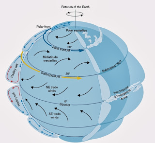

Global warming could change wind patterns because the wind will travel farther and it wont cool and sink back to the equator. This could make the wind patterns go crazy.
Friday, November 22, 2013
Island ACtivity
When developing an island there is a lot to be concerned about. The biggest problem with developing is that we didn't want to ruin the natural processes of the island. We put the houses and the resort on the ends of the island so that it would not ruin the mangroves or natural wildlife on the east and west side. We put the science center near the sea turtle nesting site on the east side of the island so that they could help the animals and make sure that the natural island processes are going well. There are docks all along the island so that boats can be docked. The center of the island is dedicated to nature. There is no development in the center of the island. I think the foot print of our island is very small. We tried to only develop in small areas so there would be less pollution etc. on the island.


Friday, November 8, 2013
A Beach by Any Other Name
“A Beach By Any Other Name”
1.
Physical and geological characteristics used to
classify Earth’s dynamic coastlines are bays, capes, coves, gulfs, headlands,
and peninsulas. Also, different types of
sands such as silt, cobbles, and gravel are used to identify coastlines.
2.
A. Shepard Coastal Classifications
a.
Acadia National Park, Maine – Primary, land
erosion, fjord
b.
Cape Cod, Massachusetts – Primary, glacial
erosion
c.
Chesapeake Bay, Virginia – Primary, drowned
river valley
d.
Atlantic City, New Jersey – primary, drowned
river valley
e.
Mississippi Delta, Mississippi – Primary,
partially drowned delta
f.
Kilauea Coast, Hawaii – primary, volcanic
eruption
g.
San Francisco Bay, California – primary, flooded
river
h.
North Carolina’s Outer Banks – secondary,
barrier islands
i.
Indian River Lagoon, Florida- secondary, marine
deposition
j.
Puget Sound, Washington- primary, fjord
k.
South Florida/Florida Keys- secondary, coral
reefs
l.
Strait of Juan Defuca, Washington- primary,
glacial erosian
m.
Cape Canaveral, Florida- secondary, barrier
islands
n.
Aleutian Islands, Alaska- primary, volcanic
o.
Florida Gulf Coast- secondary, wave erosion fault
line
p.
Texas Gulf Coast – Secondary, irregular through
wave erosion
q.
Myrtle Beach, South Carolina – Primary, land
erosion, dune coasts
r.
Prince William Sound, Alaska – Primary, lava
flow coast

Friday, November 1, 2013
Sand Reflection
In the sand lab, I was very interested by the features of the sand. It is cool to see that there is more to the sand than meets the eye. There are many different things to look at when observing the sand. The catagories include size, shape,texture, magnitude, composition, and color. Most sand was well sorted. There was alot that was composed of rock and some had shell pieces and coral also. On the Wentworth scale, most of the sand was one mm big. Many of the sand samples that I observed came from continental crust and areas where the waves were more calm, resulting in angular shape and light colors. Looking at the sand through the microscope was very cool. I took the picture below of sand from Cancun, Mexico.

Friday, October 25, 2013
Bathymetric Mapping
How can ocean floor features be measured and mapped using
current acoustical technology? How can ocean floor maps be used in the
commercial, military, and/or private sector?
Ocean floor features are mapped using sonar. Sound is bounced off the ocean floor, the rate at which it comes back shows what the floors look like. Ocean floor maps are used to navigate the ocean so no one hits a ridge or goes over a section where magma might be flowing out.  |
| A map of the ocean floor |
Friday, October 18, 2013
Theory of Continental Drift
During the "dance of the continents" activity, I learned that thousands of years ago, all of earths land was one large land mass with one big ocean. The continent broke apart because of plate tectonics, the belief that earths crust is six large plates which continually move along earths surface. Another factor to the theory of continental drift is the idea of seafloor spreading, which is the theory that there are cracks in the seafloor where magma pours out and then cools, making new crust which slowly pushes away the old crust, enlarging the seafloor.
Scientists share information with each other in order to strengthen their theories. Without the theories of seafloor spreading and plate tectonics, then Wegner's theory of continental drift would not have enough information to back it up. I believe that these theories are real and that there really was one large continent that moved apart, and that in the future our Earth will look much different.
 |
| My picture of Pangea |
Friday, October 4, 2013
Experimental Design
If I was to design an experiment for studying the mating habits of clams I would make sure to bring a lot of food. Because it takes like a week to get there and a week to get back you would probably stay a week so you need like three weeks worth of food. You would also need diving equiptment such as wet suits, flippers, goggles, and oxygen tanks. I would bring an underwater flashlight because the clams mate at night. I would also bring a camera to take pictures of the mating clams. Id bring little jars to collect samples in. This is what I would bring for my experiment.
Friday, September 20, 2013
Underwater Observatories
Building an underwater exploratory looks very cool. It seems hard to do under the water. I think that I would like to visit an underwater exploratory because I really like the ocean. They get to see lots of cool things underwater.
When building an underwater exploratory there is a lot to consider. There has to be a lot of planning before they start. They have to consider how big to make the observatory ands what materials to make it out of. They need the proper equipment. Underwater observatories are important because some of the methods used to explore the ocean are difficult and not the best choice when looking at things such as underwater volcanoes. Overall, underwater observatories are a benefit to modern-day ocean exploration.
http://theterramarproject.org/thedailycatch/worlds-largest-underwater-observatory-will-enable-real-time-interactive-ocean-study/
http://www.interactiveoceans.washington.edu/file/Dive+R1604
 |
| http://switchboard.nrdc.org/blogs/fbeinecke/global_coral_bleaching_another.html |
http://theterramarproject.org/thedailycatch/worlds-largest-underwater-observatory-will-enable-real-time-interactive-ocean-study/
http://www.interactiveoceans.washington.edu/file/Dive+R1604
Saturday, September 14, 2013
Why Explore the Oceans?
After watching the explorer presentations, my knowledge of the oceans has expanded. The explorers were very smart. I found it really interesting that they learned to navigate the oceans through looking at the constellations, the currents, and the weather. I also found it interesting that these ancient peoples were able to come up with pretty advanced technology. The compass was a life changing invention. Also, the idea of latitude and longitude maps, and that the Earth is a sphere, were pretty big discoveries. The explorers did a lot of traveling. It really surprised me that they were capable of building ships that could go out on the open oceans for long periods of time. The ancient ocean explorers were extremely smart people.
The work of ancient explorers has been helpful in ocean exploration today. Despite fancy new technology, like GPS, techniques like using the constellations, currents, and weather are still valuable ways of navigating today. I am amazed that the oceans have been explored for thousands of years, and yet there is still so much unknown. The ocean is a truely a mysterious place. I can't wait to continue to learn more about it.
Friday, September 6, 2013
Why study science?
I am taking oceanography because it seemed interesting. I have always been interested in the ocean. I also really enjoy science and learning new information on how things work. Overall, I think this will be a good course for me.
Subscribe to:
Posts (Atom)